Boundary data for all embargo areas
- download boundary data as Google Earth Placemark (KMZ format)
- download boundary data as Shapefile (zip folder)
Formats for spatial data
We provide embargo area boundaries in 2 formats.
Shapefiles
Shapefiles are a common GIS spatial data format. We do not apply any generalisation to embargo areas represented in shapefiles.
Placemarks
Software such as Google Earth can display the spatial data in Placemark files. These files are also known as Keyhole Markup Language (KML) files.
Some software that you can use to view Placemark files has limitations. To overcome these, we apply generalisation to the way we represent some embargo areas. Where we do this, we add a statement in the Placemark about the level of generalisation.
Datums and coordinate systems
We provide embargo area data using GDA94 geographic coordinates.
KML file specifications mandate the use of the WGS84 geographic coordinates. The Inter-governmental Committee on Surveying and Mapping advises that GDA94 coordinates are accurate enough to be a substitute.
Definitions of geographic areas
“Australia”
The definition of Australia, when used in a geographical sense, includes:
- Australia and its territorial sea
- the external territories and their territorial seas
- the offshore areas of the states and territories (when this relates to the exploration or exploitation of resources on the continental shelf of Australia or of an external territory)
- the Western Greater Sunrise area ( when this relates to the exploration or exploitation of resources in the Greater Sunrise unit reservoirs)
Other terms we may use to mean “Australia” are:
- "Australia or its territories"
- "Australia or its territories and adjacent areas"
- “throughout Australia"
- "Australia-wide"
“Territorial seas”
The United Nations Convention on the Law of the Sea defines "territorial sea". Where an embargo area excludes external territories, this also excludes their territorial sea.
“Offshore areas”
The term "offshore area" means the same as in the Offshore Petroleum and Greenhouse Gas Storage Act 2006.
Offshore area boundaries come from Geoscience Australia’s maritime boundary data. These boundaries are subject to change and we update embargo area data when they change.
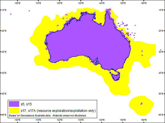
Map of Australia’s geographic area
The map shows Australia and its offshore areas. These are part of Australia, defined in sections 17 and 17A of the Radiocommunications Act 1992. Where an embargo is in place, we use the same colours to show those areas in placemark data or shapefile data.